[Home]
Currently, water level (H) measurements are accessible through Dewetra. Potentially, the platform can also integrate e display discharge (Q) observations and forecasts:
- Q observations, integrating directly discharge in the Database or translating water levels, (H) where a rating curve is available (H-Q relation).
- Q forecasts, displaying the forecasted hydrograph resulting from model simulations.
¶ Displaying discharge forecasts
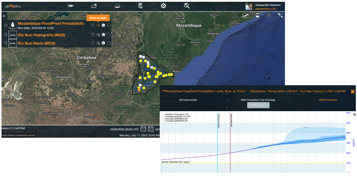
The Dewetra platform can integrate and display hydrological forecast products (time series), made available by hydrological models. Operational discharge forecasts are available and accessible in Bolivia, Guyana (CIMH Platform), Italy, Mozambique.
To configure a dynamic layer integrating and displaying hydrological forecasts, the following steps should be undertaken:
- save outputs in a fixed data format
- save outputs in a well-defined data directory and name
- location (river section) shapefile creation
- configuration of the dynamic component
- publication in Django
¶ Output data format
Hydrological forecast outputs should be available in a fixed .json format, containing the time series and additional information about timing, location, frequency, thresholds and model run configuration. An example of the a .json output for the Rio Revue at Messica section (Buzi river, Mozambique) is provided hereafter.
{
    "run_domain": "buzi",
    "run_mode": "deterministic",
    "run_name": "nwp_gfs-det",
    "run_var": "deterministic",
    "section_baseflow": "0.0",
    "section_code": "None",
    "section_discharge_thr_alarm": "368.65",
    "section_discharge_thr_alert": "184.07",
    "section_discharge_thr_emergency": "608.93",
    "section_domain": "buzi",
    "section_drained_area": "749.0",
    "section_id": "12",
    "section_idx_i": "66",
    "section_idx_j": "23",
    "section_idx_ji": "23,66",
    "section_name": "Rio_Revue_at_Messica",
    "section_reference": "buzi",
    "time_period": "2023-05-20 23:00,2023-05-21 00:00,2023-05-21 01:00,2023-05-21 02:00,2023-05-21 03:00,2023-05-21 04:00,2023-05-21 05:00,2023-05-21 06:00,2023-05-21 07:00,2023-05-21 08:00,2023-05-21 09:00,2023-05-21 10:00,2023-05-21 11:00,2023-05-21 12:00,2023-05-21 13:00,2023-05-21 14:00,2023-05-21 15:00,2023-05-21 16:00,2023-05-21 17:00,2023-05-21 18:00,2023-05-21 19:00,2023-05-21 20:00,2023-05-21 21:00,2023-05-21 22:00,2023-05-21 23:00,2023-05-22 00:00,2023-05-22 01:00,2023-05-22 02:00,2023-05-22 03:00,2023-05-22 04:00,2023-05-22 05:00,2023-05-22 06:00,2023-05-22 07:00,2023-05-22 08:00,2023-05-22 09:00,2023-05-22 10:00,2023-05-22 11:00,2023-05-22 12:00,2023-05-22 13:00,2023-05-22 14:00,2023-05-22 15:00,2023-05-22 16:00,2023-05-22 17:00,2023-05-22 18:00,2023-05-22 19:00,2023-05-22 20:00,2023-05-22 21:00,2023-05-22 22:00,2023-05-22 23:00,2023-05-23 00:00,2023-05-23 01:00,2023-05-23 02:00,2023-05-23 03:00,2023-05-23 04:00,2023-05-23 05:00,2023-05-23 06:00,2023-05-23 07:00,2023-05-23 08:00,2023-05-23 09:00,2023-05-23 10:00,2023-05-23 11:00,2023-05-23 12:00,2023-05-23 13:00,2023-05-23 14:00,2023-05-23 15:00,2023-05-23 16:00,2023-05-23 17:00,2023-05-23 18:00,2023-05-23 19:00,2023-05-23 20:00,2023-05-23 21:00,2023-05-23 22:00,2023-05-23 23:00,2023-05-24 00:00,2023-05-24 01:00,2023-05-24 02:00,2023-05-24 03:00,2023-05-24 04:00,2023-05-24 05:00,2023-05-24 06:00,2023-05-24 07:00,2023-05-24 08:00,2023-05-24 09:00,2023-05-24 10:00,2023-05-24 11:00,2023-05-24 12:00,2023-05-24 13:00,2023-05-24 14:00,2023-05-24 15:00,2023-05-24 16:00,2023-05-24 17:00,2023-05-24 18:00,2023-05-24 19:00,2023-05-24 20:00,2023-05-24 21:00,2023-05-24 22:00,2023-05-24 23:00,2023-05-25 00:00,2023-05-25 01:00,2023-05-25 02:00,2023-05-25 03:00,2023-05-25 04:00,2023-05-25 05:00,2023-05-25 06:00,2023-05-25 07:00,2023-05-25 08:00,2023-05-25 09:00,2023-05-25 10:00,2023-05-25 11:00,2023-05-25 12:00,2023-05-25 13:00,2023-05-25 14:00,2023-05-25 15:00,2023-05-25 16:00,2023-05-25 17:00,2023-05-25 18:00,2023-05-25 19:00,2023-05-25 20:00,2023-05-25 21:00,2023-05-25 22:00,2023-05-25 23:00,2023-05-26 00:00,2023-05-26 01:00,2023-05-26 02:00,2023-05-26 03:00,2023-05-26 04:00,2023-05-26 05:00,2023-05-26 06:00,2023-05-26 07:00,2023-05-26 08:00,2023-05-26 09:00,2023-05-26 10:00,2023-05-26 11:00,2023-05-26 12:00,2023-05-26 13:00,2023-05-26 14:00,2023-05-26 15:00,2023-05-26 16:00,2023-05-26 17:00,2023-05-26 18:00,2023-05-26 19:00,2023-05-26 20:00,2023-05-26 21:00,2023-05-26 22:00,2023-05-26 23:00,2023-05-27 00:00,2023-05-27 01:00,2023-05-27 02:00,2023-05-27 03:00,2023-05-27 04:00,2023-05-27 05:00,2023-05-27 06:00,2023-05-27 07:00,2023-05-27 08:00,2023-05-27 09:00,2023-05-27 10:00,2023-05-27 11:00,2023-05-27 12:00,2023-05-27 13:00,2023-05-27 14:00,2023-05-27 15:00,2023-05-27 16:00,2023-05-27 17:00,2023-05-27 18:00,2023-05-27 19:00,2023-05-27 20:00,2023-05-27 21:00,2023-05-27 22:00,2023-05-27 23:00,2023-05-28 00:00,2023-05-28 01:00,2023-05-28 02:00",
    "time_restart": "202305202300",
    "time_run": "202305230000",
    "time_series_air_temperature_observed": "-9998.0,15.3,15.3,15.2,15.0,14.8,15.7,17.9,20.0,22.0,24.3,26.1,26.9,26.9,26.6,25.2,22.1,19.3,18.0,17.3,16.9,17.0,16.8,16.1,15.9,15.5,15.5,15.4,15.5,15.5,17.0,21.0,24.1,26.0,27.1,27.9,28.2,27.2,25.5,23.3,21.0,19.8,18.6,18.4,18.0,17.3,16.2,15.8,15.0,13.9,13.9,14.5,15.2,15.4,15.9,16.8,17.8,18.9,19.8,20.9,21.9,22.2,21.9,20.6,18.7,16.4,16.5,16.4,15.9,15.6,15.1,14.7,14.5,14.2,14.1,14.3,14.2,14.1,15.0,17.3,19.6,21.8,23.8,25.5,26.3,26.3,25.8,24.4,20.8,17.5,16.6,15.8,15.2,14.6,14.4,14.2,14.0,13.9,13.6,13.4,13.2,13.1,14.5,17.8,20.6,22.9,24.4,25.3,25.7,25.8,25.3,24.3,21.0,17.9,16.6,15.5,14.7,14.2,13.9,13.8,13.7,13.5,13.3,13.2,13.0,12.7,14.4,18.1,21.5,23.8,25.3,26.2,26.7,26.7,26.2,25.0,21.0,18.1,17.0,16.0,15.0,14.3,13.8,13.5,13.1,12.7,12.3,12.1,11.8,11.6,12.8,16.0,18.3,20.2,21.6,22.8,23.5,23.8,23.5,22.4,19.1,15.6,14.1,13.4,12.8,12.2,11.5,10.9,10.6,10.4,-9998.0,-9998.0",
    "time_series_discharge_observed": "-9997.0,-9997.0,-9997.0,-9997.0,-9997.0,-9997.0,-9997.0,-9997.0,-9997.0,-9997.0,-9997.0,-9997.0,-9997.0,-9997.0,-9997.0,-9997.0,-9997.0,-9997.0,-9997.0,-9997.0,-9997.0,-9997.0,-9997.0,-9997.0,-9997.0,-9997.0,-9997.0,-9997.0,-9997.0,-9997.0,-9997.0,-9997.0,-9997.0,-9997.0,-9997.0,-9997.0,-9997.0,-9997.0,-9997.0,-9997.0,-9997.0,-9997.0,-9997.0,-9997.0,-9997.0,-9997.0,-9997.0,-9997.0,-9997.0,-9997.0,-9997.0,-9997.0,-9997.0,-9997.0,-9997.0,-9997.0,-9997.0,-9997.0,-9997.0,-9997.0,-9997.0,-9997.0,-9997.0,-9997.0,-9997.0,-9997.0,-9997.0,-9997.0,-9997.0,-9997.0,-9997.0,-9997.0,-9997.0,-9997.0,-9997.0,-9997.0,-9997.0,-9997.0,-9997.0,-9997.0,-9997.0,-9997.0,-9997.0,-9997.0,-9997.0,-9997.0,-9997.0,-9997.0,-9997.0,-9997.0,-9997.0,-9997.0,-9997.0,-9997.0,-9997.0,-9997.0,-9997.0,-9997.0,-9997.0,-9997.0,-9997.0,-9997.0,-9997.0,-9997.0,-9997.0,-9997.0,-9997.0,-9997.0,-9997.0,-9997.0,-9997.0,-9997.0,-9997.0,-9997.0,-9997.0,-9997.0,-9997.0,-9997.0,-9997.0,-9997.0,-9997.0,-9997.0,-9997.0,-9997.0,-9997.0,-9997.0,-9997.0,-9997.0,-9997.0,-9997.0,-9997.0,-9997.0,-9997.0,-9997.0,-9997.0,-9997.0,-9997.0,-9997.0,-9997.0,-9997.0,-9997.0,-9997.0,-9997.0,-9997.0,-9997.0,-9997.0,-9997.0,-9997.0,-9997.0,-9997.0,-9997.0,-9997.0,-9997.0,-9997.0,-9997.0,-9997.0,-9997.0,-9997.0,-9997.0,-9997.0,-9997.0,-9997.0,-9997.0,-9997.0,-9997.0,-9997.0,-9997.0,-9997.0,-9997.0,-9997.0,-9997.0,-9997.0",
    "time_series_discharge_simulated": "-9998.0,0.0,0.0,0.0,0.0,0.0,0.0,0.0,0.0,0.0,0.0,0.0,0.0,0.0,0.0,0.0,0.0,0.0,0.0,0.0,0.0,0.0,0.0,0.0,0.0,0.0,0.0,0.0,0.0,0.0,0.0,0.0,0.0,0.0,0.0,0.0,0.0,0.0,0.0,0.0,0.0,0.0,0.0,0.0,0.0,0.0,0.0,0.0,0.0,0.0,0.0,0.0,0.0,0.0,0.0,0.0,0.0,0.0,0.0,0.0,0.0,0.0,0.0,0.0,0.0,0.0,0.0,0.0,0.0,0.0,0.0,0.0,0.0,0.0,0.0,0.0,0.0,0.0,0.0,0.0,0.0,0.0,0.0,0.0,0.0,0.0,0.0,0.0,0.0,0.0,0.0,0.0,0.0,0.0,0.0,0.0,0.0,0.0,0.0,0.0,0.0,0.0,0.0,0.0,0.0,0.0,0.0,0.0,0.0,0.0,0.0,0.0,0.0,0.0,0.0,0.0,0.0,0.0,0.0,0.0,0.0,0.0,0.0,0.0,0.0,0.0,0.0,0.0,0.0,0.0,0.0,0.0,0.0,0.0,0.0,0.0,0.01,0.02,0.06,0.13,0.23,0.35,0.49,0.61,0.72,0.82,0.89,0.96,1.01,1.05,1.09,1.12,1.15,1.18,1.21,1.24,1.27,1.31,1.35,1.39,1.44,1.48,1.53,1.57,1.62,1.66,1.69,1.72,1.74,1.76,1.78,1.79",
    "time_series_rain_observed": "-9998.0,0.0,0.0,0.0,0.0,0.0,0.0,0.0,0.0,0.0,0.0,0.0,0.0,0.0,0.0,0.0,0.0,0.0,0.0,0.0,0.0,0.0,0.0,0.0,0.0,0.0,0.0,0.0,0.0,0.0,0.0,0.0,0.0,0.0,0.0,0.0,0.0,0.0,0.0,0.0,0.0,0.0,0.0,0.0,0.0,0.0,0.0,0.0,0.0,0.0,0.0,0.0,0.0,0.0,0.0,0.0,0.0,0.0,0.1,0.0,0.0,0.0,0.0,0.0,0.0,0.1,0.0,0.0,0.0,0.0,0.0,0.0,0.0,0.0,0.0,0.0,0.0,0.0,0.0,0.0,0.0,0.0,0.0,0.0,0.0,0.0,0.0,0.0,0.0,0.0,0.0,0.0,0.0,0.0,0.0,0.0,0.0,0.0,0.0,0.0,0.0,0.0,0.0,0.0,0.0,0.0,0.0,0.0,0.0,0.0,0.0,0.0,0.0,0.0,0.0,0.0,0.0,0.0,0.0,0.0,0.0,0.0,0.0,0.0,0.0,0.0,0.0,0.0,0.0,0.0,0.0,0.0,0.0,0.0,0.0,0.0,0.0,0.0,0.0,0.0,0.0,0.0,0.0,0.0,0.0,0.0,0.0,0.0,0.0,0.0,0.0,0.0,0.0,0.0,0.0,0.0,0.0,0.0,0.0,0.0,0.0,0.0,0.0,0.0,0.0,0.0,0.0,0.0,0.0,0.0,-9998.0,-9998.0",
    "time_series_soil_moisture_simulated": "-9998.0,0.2,0.2,0.2,0.2,0.2,0.2,0.2,0.2,0.2,0.2,0.2,0.2,0.2,0.2,0.2,0.2,0.2,0.2,0.2,0.2,0.2,0.2,0.2,0.2,0.2,0.2,0.2,0.2,0.2,0.2,0.2,0.2,0.2,0.2,0.2,0.2,0.2,0.2,0.2,0.2,0.2,0.2,0.2,0.2,0.2,0.2,0.2,0.2,0.2,0.2,0.2,0.2,0.2,0.2,0.2,0.2,0.2,0.2,0.2,0.2,0.2,0.2,0.2,0.2,0.2,0.2,0.2,0.2,0.2,0.2,0.2,0.2,0.2,0.2,0.2,0.2,0.2,0.2,0.2,0.2,0.2,0.2,0.2,0.2,0.2,0.2,0.2,0.2,0.2,0.2,0.2,0.2,0.2,0.2,0.2,0.2,0.2,0.2,0.2,0.2,0.2,0.2,0.3,0.3,0.3,0.3,0.3,0.3,0.2,0.2,0.2,0.2,0.2,0.3,0.3,0.3,0.3,0.3,0.3,0.3,0.3,0.3,0.3,0.3,0.3,0.3,0.3,0.3,0.3,0.3,0.3,0.3,0.3,0.3,0.3,0.3,0.3,0.3,0.3,0.3,0.3,0.3,0.3,0.3,0.3,0.3,0.3,0.3,0.3,0.3,0.3,0.3,0.3,0.3,0.3,0.3,0.3,0.3,0.3,0.3,0.3,0.3,0.3,0.3,0.3,0.3,0.3,0.3,0.3,0.3,0.3",
    "time_start": "202305210000"
}
¶ Output data directory and name
Hydrological forecasts should be saved in a well structured manner to be integrated in the DDS:
{PRODUCT-NAME}/{YYYY}/{MM}/{DD}/filename.jsonWhere YYYY is the year (e.g., 2023), MM the month (e.g, 05) and DD the day (e.g, 23).
Filename also should have a fixed format:
hydrograph_{section-name}_{basin-name}_YYYYMMDDHHMM.jsonWhere section-name is the name of the river section as reported in the shapefile (see next paragraph), basin-name is the name of the watershed, YYYY is the year (e.g., 2023), MM the month (e.g, 05), DD the day (e.g, 23), HH the hour (e.g., 12) and MM the minutes (e.g., 00).
¶ Location vector file (point)
To map the output files with the corresponding river sections, a vector file (point) is needed. The point shapefile should represent the location (in geographic projection, WGS84, EPSG:4326) and should contain the following fields:
| ID | SEC_CODE | SEC_NAME | BASIN | TYPE | Q_THR1 | Q_THR2 | Q_THR3 |
Where:
- ID: is the unique number of the point feature
- SEC_CODE: is the unique identification number of the river section
- SEC_NAME: is the river section name (should match with the one in the file name {section-name})
- BASIN: is the watershed name (should match with the one in the file name {basin-name})
- TYPE: river or dam
- Q_THR1: lowest warning threshold for the river section, in m3/s
- Q_THR2: medium warning threshold for the river section, in m3/s
- Q_THR3: highest warning threshold for the river section, in m3/s
[Home]